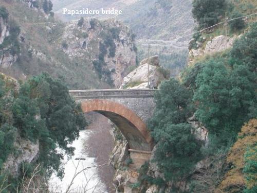
Scalea, its historic centre a maze of streets with arches, steps, and a splendid seafront below, also has the Talao Grotto, where Paleolithic remains have been found. Behind lie other places of interest such as Papasidero.
A straight road leads to Cirella, while on a rocky site slightly inland stand Maiera and Grisolia, two small villages barely separated by a valley. Cirella Marina is a restful spot in the middle of olive groves, just below the ruins of the old village, further away from the water, where ruined churches and buildings lie in total silence.
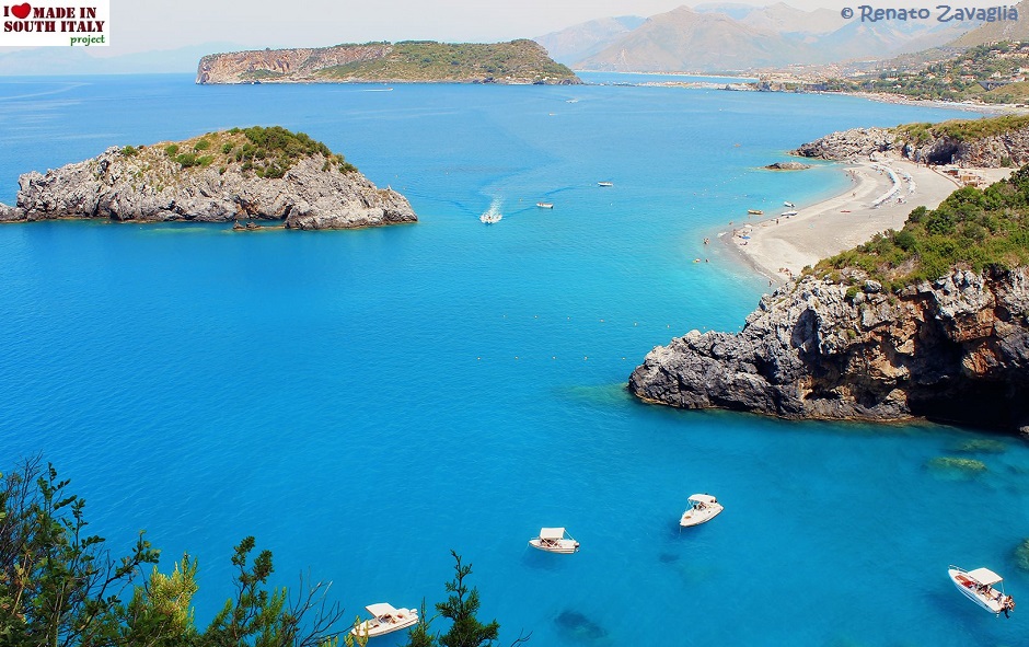
Facing the sand and pebble beach, 4 km long and 40 m wide, is a 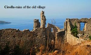 deserted rocky island, the delight of snorkellers and those who love the characteristic Mediterranean vegetation.
The beach is wider (about 200m) at Diamante and the water crystal clear.
Citrons also flourish at Diamante and together with the beautiful beach and water, this helps to make a popular holiday resort.
The soil here is ligumusa,i.e. full of stones that the streams have deposited but it is particularly suitable for the citron, which is used in making essences, liqueurs and candied fruit.
It is also widely used at Jewish feasts. The Jews regard it as the purest of fruits and the rabbies come in August to pick it themselves.Citrons are the town's second source of income, after tourism.
Belvedere, slightly futher south,has another characteristic: a kind of clay, derived from the calangues and fiumare, enabling potters to carry on their old tradition.
There is even a church completely decorated with ceramics.
 Though scarcely possible to name all the villages along the coast, some should be mentioned: Sangineto, Cetraro, Acquappesa, Guardia, Fuscaldo, Paola Marina, San Lucido and Amantea.
All have spendid beaches, where the cooling presence of the Catena Costiera lying parallel to the sea, with its woodland and glades, mitigates the summer heat. The coast streches more or less unchanged with a series of towns and villages,and fine sandy beaches.
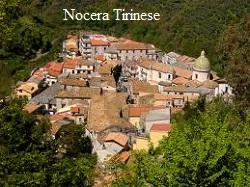 Nocera Tirinese, about 8 km from the sea, is particularly interesting; apart from its many churches and old buildings, well conserved, the town is structured on different levels, with flight of steps.
This enhances the annual Good Friday Passion Play, of which the town is very proud. The town itself becomes the stage, and flagellants, wearing a crown of thorns, scourge their naked thighs with barbed whips till the blood flows, thus creating a dramatic scene.
Back to the coast, farther south, the San'Eufemia plain comes into sight and the beach narrows. The main road and the motorway run slightly away from the sea, old watch towers are now more frequent, with ruined abbeys standing beside new agricultural villages which have developed after land reclamation.
The inhabitants themselves began the immense task of totally reclaming the once malaria-infested marshes on the plain, and turning them into rich intensively cultivable arable land.
In fact, Calabria's busiest airport (Sant'Eufemia Lamezia) was sited there, taking its name from the ancient city of Lametia.
The Due Mari (the two seas) motorways, linking Sant'Eufemia and  Catanzaro Marina, also starts here, lined with vineyards, olive groves and farms where local produce can be purchased.
The wide Gulf of San'Eufemia is an intensively cultivated plain with vineyards, beetroot, strawberries, raspberries, green vegetables and flowers (you also find many hotels and campsites), but further on, towards Pizzo, the coastline rises, with rugged cliffs.
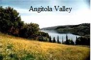 Piana dell Angitola is an interesting deserted village at the top of an artificial lake of the same name, formed by damming the Angitola and Reschia rivers.
Higher up are glades with reed beds and oaks, olives and the occasional ancient acacia. In the lake below,great dead branches stick out of the water and a reed barrier lies toward the sea, wrapped in silence, broken by the occasional lone camper wanting to be within reach of the sea, lake and mountains, all in a matter of minutes.
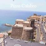 Ahead lies Pizzo,one of the liveliest and interesting little towns, in terms of history, art and natural beauty.
The destination of those in search of an intelligent holiday, Pizzo is perched on the edge of a cliff, and provides pleasure for marine enthusiasts as well as lovers of history and traditions.
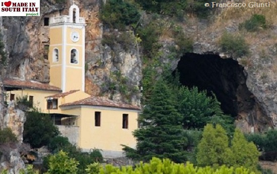
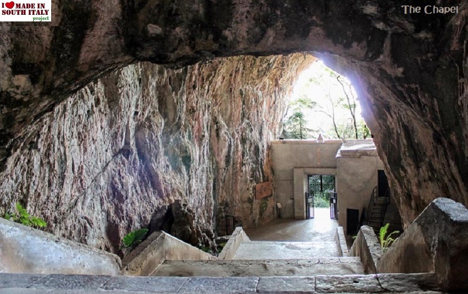
From the broken line of cliffs along the irregular coastline, visitors can watch the tuna fishing, known as the 'tonnara', but a whole morning can be easily spent in the yards where boats are still made by craftsmen, or visiting a potter's workshop; then a late afternoon swim can be taken from the sandy beaches or from the rocks beside the little church of Piedigrotta or Fuorigrotta, hollowed out of the tufa; just beyond the water's edge.
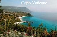 The visitor is now close to the Capo Vaticano promontory, but must first pass through Vibo Marina, on an inlet in the Gulf of Sant'Eufemia.
On a clear day, from highway 18, the view extend to last foothills of the Catena Costiera, the Serre and even as far as the Stromboli vulcan (Sicily). After the chief town, Vibo Marina is the main Tyrrhenian port, used mainly by pleasure boats.
The beach, longer south of the port, is about 2 km long and 50 m. wide; it is sandy, with rolling dunes of vatious heights.
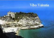 Vibo Valentia, in the hills at an altitude of 500m. has approx.30,000 inhabitants and a precise urban layout; it maintains great interest in its archeological past together with marked industrial development (cement, resins, wine and food).
Tropea,the best known town on the whole promontory, is a sort of acropolis between the Gulf of Sant'Eufemia and Gioa Tauro; most of the tourist villages have been built in this area.
 Nature itself, or rather, the rugged structure of the land, dictates that everything, from plants to tourist facilities, shall be located on cliff terraces, at times sloping toward the water.
The houses are often hidden from the sight and outlying rocks separate the beaches lying at the foot of the cliffs. The coast is wild and rugged,but there is a small harbor for pleasure boats, and jackdaws make their home among the rocks.
Tropea is a quality resort, for its natural scenic beauty and its elegant historic centre, an enormous Baroque "balcony" facing San Leonardo and Santa Maria dell ' Isola, once islands, but now joined to the mainland.
The characteristic produce of this area, onions, giant lettuce,grapes, citrus fruit and olives, is very well known. Giuseppe Berto, the writer, was an honorary citizen of the town for years before his death, and many people used to visit his house; on a steep hill overlooking the sea, it is surrounded by fields of lettuce and the onions he loved to cook in so many different ways.
Past Capo Vaticano and the Nicotera Marina area, of considerable archaeological interest, lies the Costa Viola (Violet Cost), starting at Rosarno.
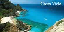 Apparently the coast gets its name from its sunsets. The road here runs high above the sea and visitors feel they are traveling along the edge of a precipice. Small steep roads,however,give access to the sea. Farther south,the road draws closer to the sea,winding through ancient olive groves, perhaps amongst the most renowned in Italy; one tree can produce up to 140 litres of oil.
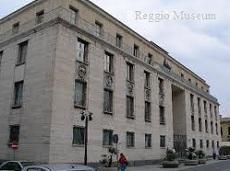
The Rosarno Plain became a rich agricoltural after reclamation, begun by the Marquis Nunziante in 1818, and continued by his heirs. The site of the Greek colony of Medma (founded by the people of Locri in the 6th century BC) archeological finds were discovered here, including the famous Medma terracottas, now in the Reggio Museum.
The Rosarno marina is at San Ferdinando, a town created by the 1820 reclamation project, with a low,fairly wide beach. Camping facilities are good and the citrus fruits excellent.
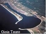 Gioia Tauro is the most important centre in the Gulf of the same name characterized by the industrial port of the Quinto Iron works, now closed.
Here as well there have been many archaeological finds. In addition to the fruit industries there are tourist facilities at Marina di Gioa Tauro and a low-lying, wide sandy beach.
The beach of Palmi and Lido di Palmi are sqeezed between the sea and the western foothills of the Aspromonte, perpendicular to the sea. Taureana,the ancient Tauroentum,gives the impression of being much higher above the sea.
Monte San'Elia (580 m) rises a few km away, covered with pine forest with camping and tourist facilities as well as a beautiful view from Nicotera to the north as far as the Aeolian Islands, with Aspromonte behind.
The Grotta of San'Elia at Melicucca' is very interesting only 4 km away. At the foot of this mountain is the small beach of Marinella, deserted amidst high jagged cliffs,with a fresh water spring, surrounded by fishermen's houses, nearly all now abandoned. The place seems created for scuba divers.
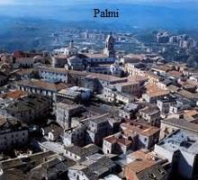 Palmi is very important as a commercial industrial, agricoltural and historical centre. Almost completely rebuilt following the earthquake of 1908, it dominates the coast which lies at a distance of 2 km.
It has one of the best and biggest libraries in Calabria, the Cilea Museum and the Civic Museum of Ethnography and Folklore, divided into various sections on agricultural life; seafaring, popular traditions, magic and the aspects of life of the people of this area who have lived emarginated for centuries, often relying on imagination as their only relief from solitude.
The museum, which exhibits about 300 examples of craft work, is one of the few of its type in existence and it is certainly the most important of those preserving relics of the culture of agricultural communities.
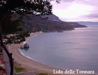 The Lido della Tonnara promenade is very pleasant and facing it lies the small island called the 'Rock of the Olive Tree', a large rock mass surmounted by an olive tree that has weathered storms and tempests almost protecting the caves accessible only from the sea.
Four km from Palmi, along the road flanked by olive groves, lies Seminara, a lively centre with a very old tradition of craftsmanship, especially terracotta, a craft handed down from father to son and of Greek origin,characterized by its bright colours and intricate design. The most famous piece is the so-called 'babbalatu', a bottle in the shape of a man.
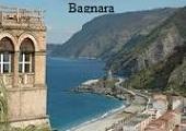 Bagnara, on the Violet Coast, is almost crushed between the sea (the new town), and the rocks where old houses are perched.
The beach here is almost a surprise, for it is wide and sandy, contrasting sharply with the rocks on which the village stands.
Some famous products of this zone are torrone and glass. But Bagnara is also famous for the swordfish fishing and rivals Sicily at this. Though carried out today with modern techniques, nothing of the existing cruel ceremony of olden times has changed.
The method used is really an ancient rite which seems to have been brought by the Phoenicians. It is done with the 'passarella', a motor boat with an outboard deck for the harpoonist and a 20 meter high pole with a perch for the helmsman-lookout. The fishing take place in the period when the swordfish approach these beaches,i.e. from April to June.
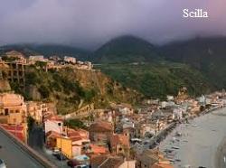 Scilla appears as a dream come true and the echoes of its legendary existence are still strong.
This is one of those places of the spirit, and so some rhetoric will be forgiven. The 17th and 18th century houses and buildings alternate with the cheerful cottages of the "Chianalea" fishrman; standing at the age of the sea they look as if they will fall in any minute.
Two amphitheatres of construction frame the crag dominated by the Castle, now a Youth Hostel. Arches and roofed passages unite the Chianalea houses where life is lived with waves and storms in the wisdom of centuries of experience.
The winding road continually passes the red roofs and dominates the slooping beach. Nearby is the entrance to the karst caves of Tremusa, rich in stalactites.
There is a special atmosphere,especially on calm days, of good weather and the memory of ancient legends which move us to search for sirens, those enchanting nymphs that sing from sheer cliffs.Sicily lies only a few km away.
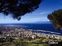 Once past Villa San Giovanni pier, we approach Catona and Gallico, elegant beaches before Reggio di Calabria.
Strictly speaking, Reggio is not a resort, but can be defined as one of the principals towns in the Region where bathing is possible. Located on the sea, with Aspromonte-Gambarie behind, it has a privileged position, especially for its excellent climate.
The surrounding vegetation is very profuse, with citrus groves (Bergamot essence is used for parfumes), vineyards and olive groves in the hills, while farther inland stand pine,chestnut, beech and fir woods. There are also many tropical plants such as date palm, the banana, the magnolia and the rubber tree.
Many of these species can be seen along the Lungomare which D'Annunzio described as the most beautiful kilometre in Italy,and in the Villa Comunale, its continuation.
This was created in 1854 as a Botanical Garden and still is today.
 Along the Lungomare lie the ruins of Greek walls and Roman Baths, alternating with recent monuments erected to famous Calabrians; also of great interest is the Experimental Essence Centre, set up to conduct studies on bergamot and jasmine.
There is also many bathing beaches. From a cultural point of view, the National Museum or Museum of Magna Grecia, formed by uniting the Cicic Museum and the Antiquarium collection, is particularly interesting, housing nearly a century of archeological finds.
The sections are: a) Calabrian prehistory and proto history, b) Greek colonization, c) Greek and Latin sculpture and inscriptions, d) coins, e)underwater archeology. This is one of the most important and best organized museums, important also from an educational point of view.
The collections were organized by archeologists such as Paolo Orsi, Adamesteanu, Lattanzi, etc. However the Museum became famous only in 1981 when it received the Riace Bronzes and the Philosopher's Head,and is now one of the places to visit in Calabria.
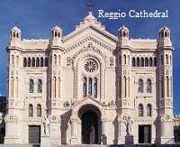 Reggio also has a beautiful Cathedral reconstructed in 1920 in neo-Romanesque style with a fine Baroque chapel of the Blessed Sacrament.
The Church of the Ottimati has been reconstructed and possesses a beautiful XI century mosaic floor, and outstanding Norman capitals on the ceiling. Little ramains of the Aragon castle-only two towers and a piece of wall.
The Basilica of the Madonna della Consolazione is a modern structure on the hill of the Eremo. Interesting for better understanding this region is the centre of documentation for the folk arts of Calabria. South of Reggio begins the Ionian beaches, spacious with fine white sand.
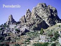 Before reaching Milito di Porto Salvo, the lively centre where Garibaldi landed before heading to Naples, the visitor should turn off for Pentedattilo, one of the most charming hamlets in Calabria.
It is called Pentedattilo (the five fingers) for it looks like fingers against Monte Calvario, with sandstone rocks practically seeming to roll against it. Five red fingers, the story says, to wash in blood the outrage perpetrated against a local baron who was denied the Lady Alberty, sister of the feudal lord of Pentedattilo, in marriage.
With its somewhat sinister appearances, the town has been long abandoned; a few old people, often shepherds, are left while the others have gone down to the seaside villages or have emigrated. And yet in the 19th century, the 2,000 'fuochi' of this town were famous for the production of honey.
The whole coast as far as Capo Spartivento, ancient Heracleum Promontorium, in the south of Calabria, and then as far as Locri, is a series of beaches, often deserted, though broken by occasional town and skirted by the railway. This is a paradise for seekers after unpolluted sea and raw nature .
 Inland are many small villages, once the refuge of shore dwellers fleeing the Saracen raiders. This is the area of the former Greek minority, now distributed over five towns : Bova, Bova Marina, Roghudi, Roccaforte del Greco and Condofuri.
The nearby town of Pietrapennata, situated in woodland, is also interestingand noted for its linen tablecloths and covers.
All around lie vineyards and citrus fruit orchards as well as clumps of wild agaves and prickly pears. Roman, Paleochristian and Byzantine remains are common. Just before Bovalino is the tutn-off for San Luca, the town Corrado Alvaro described so well in Gente in Aspromonte (People in Aspromononte). Mementoes of his life are kept there.
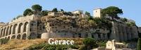 It is difficult to decide whether to visit Locri first or Gerace. Both have a wealth of art and history; Locri is on the seashore, Gerace on the hill above, Gerage is solemn but noble little town, full of art treasures; Locri is one of the main archeological centres.
There is, however also a modern Locri (c.13,000 pop.) with parallel straight streets and good tourist facilities, from hotels to campsites. Siderno and Gioiosa are fairly similar; both given over to tourism, agriculture and fishing. A visit to Canolo, among the crags known as the "Calabrian Dolomites" where craftsmen stll tan hides worth making, and also to Mammola, a medieval centre.
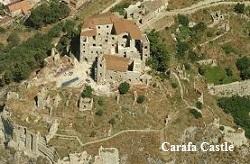 Back on the coast lies Roccella Ionica , a well known seaside resort, interesting for its higher-sited old town with the ruins of the mediaeval Carafa Castle.
The silence of upper Roccella,now almost uninhabited, is broken only by the creak of a potter's wheel. Only a few potters still work here and the objects are simply made and antique in style.
Nearby Caulonia, also on the sea, conserves the ruins of a 16th century castle.
 Farther on lies Riace Marina,now famous as it is here that the bronze statues of two warriors were found in the sea in August 1972. Seven kmaway, in the hills,stands mediaeval Riace.
Northwards, Monasterace Marina has good tourist facilities and a beautiful seafront.
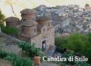
Less than 2 km away, visitors can visit the remains of Greek Caulonia and Punta Stilo, the ancient Roman Cocynthum promontory, southern extreme of the Gulf of Squillace. Here the visitor must turn inland for a visit not to be missed : Cattolica di Stilo, this fine 10th century Byzantine church is of exceptional artistic interest.
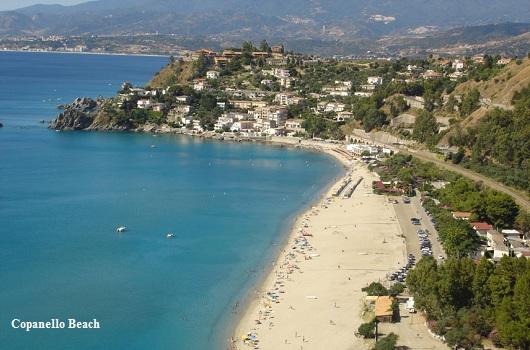
The coast road runs alongside sunny beaches, mostly pebble occasionally sandy; at Copanello, cliffs break into a rocky shoreline.
Copanello is an elegant seaside resort and excursions can be made to the grottoes, the most famous being the Grotto of San Gregorio.
The Serre behind Squillace lends it added interest. It is also an archeological centre (the ancient Skiylleiton of the Greeks), very attractive and well conserved. There are isolated beaches at the foot of the cliffs. About 1 km from Marina di Catanzaro a large redbrick building catches the eye.
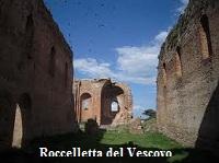 This is the Roccelletta del Vescovo di Squillace, once the basilica of Santa Maria della Roccella, the largest in the region.
Now roofless, three round apses and a nave are still standing. Perhaps Byzantine or Norman, some experts date it to around 1000 AD. Outside stands a 19th century fountain with a 6th century bas-relief,and some Roman ruins lie close by.
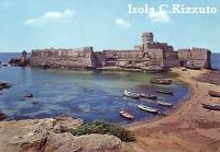
The coast is fairly straight and flat as far as Le Castella ,a hamlet of Isola Capo Rizzuto an attractive island linked to the coast at low tide and surmounted by an ancient castle. Accomodation is available in fisherman's houses, hotels and a well-equipped tourist village. The coast then becomes jagged with rocks and coves.
 Capo Rizzuto lies at the other side of the bay, one of the first villages created by a large tourist organizzation.
The surrounding desert-like landscape makes the village seem like an oasis. Above, the town of Isola di Capo Rizzuto, a reclaimed town where the new part, rather flat, like an African village, with rows of low houses and unpaved roads, contrasts strangely with the mediaeval town ; this conserves the ruins of Castello Ricca, the late Renaissence Cathedral with its Baroque facade and other old churches.
The flat ground sloping down to sea is intensively cultivated with crops of excellent vegetables. The promontory of this zone, an ex Marquisate, stretches as far as the point called Capo Colonna , the most eastern part of Calabria.
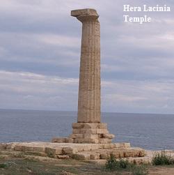 The jagged coast recalls certain stretches of the Greek coast, especially when one spots a Doric column by the sea, the only survivor from the famous Temple of Hera Lacinia, a sanctuary of the Italiots of the Gulf of Taranto.
According to historians, there were 48 columns which survived until the early 16th century when they were used for civil engineering! Beyond the Capo, the coast again becomes flat and the peninsula of Crotone can be see.
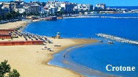
This is a city with a glorious past, still important today for its indudtries , commerce and food market. Its port is also widely used, being the only Ionian port in Calabria.
 After Crotone, the coast runs straight with miles of free beach interrupted here and there by villages built after reclamation, such as Gabella Grande and Contrada Bucchi, where cultivated fiels and farmhouses dominate the scene. Here lies the mouth of the Neto, the river of the Sila Crande, 95 km long.
More villages are developing, like Fasana, Strongoli which still has the ancient greek and Bruzian centre. There are hundreds of traces of Magna Grecia in this area extending as far as Locri to the south and Sibari to the north.
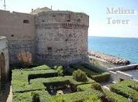 On the coast stands the watch towers of Torre Melissa, for example,whith a beautiful adjacent beach. In the hills, Melissa is known for its excellant wine but also for the tragic bloody events of 1948 which took place at the abolition of the landed estates.
A very famous wine comes from Ciro' with its marina, a busy summer resort, enclosed by walls,with a triangular structure. A very interesting town located 25 km inland is Ubriatico which, perhaps because of its name, reminds one of small Umbrian town.
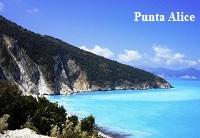 Back along the sea, there is a small Roman promontory, the Crimisa Promontorium, now Punta Alice , a seaside resort with extensive facilities for tourism, surrounded by thick pines, eucalyptus tree, acacias and oleanders.
Near the lighthouse are remains of the Temple di Apollo Aleo.
Then follow lots of other small seaside town with beaches limited by the road, but it is worth turning into the interior to visit Crucoli where fabrics with oriental design and straw bread baskets are produced. The fabrics are well made and can also be found at Cariati, ashort distance away.
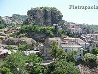 Another detour which holds surprises for the visitor leads to Pietrapaola, a medieval hamlet on the hill.
The roads ends in the village itself, which seems suspended in the clouds. About 4 km away, on Mount Orgia, there are many grottoes and caves, once used as necropoles. Near Mirto Crosia, the beach, lined with olives trees, becomes completely sandy again.
Here creeks and streams empty into the sea, cooling the area.
Nearby is one of the most important artistic centres of Calabria, Rossano, a few km from the sea and the well equipped beach of Sant'Angelo.
Facing Rossano , on a plateau, stands the Monastery of Santa Maria del Patire, restored in various periods.
The remains are for the most part 16th century though many elements are ancient.
The scenery here is beautiful with a view sweeping from the Sila Greca to the Plain of Sibari and the sea.
 Heading north along the coast, we come to Marina di Schiavonia, a spacious beach with bathing eastabilshments and citrus fruit groves.
Nearby is another sanctuary, the octagonal Santa Maria di Illirico, built over an earlier Basilian abbey.
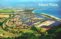
The visitor is now at the Piana di Sibari, the biggest Calabrian coastal plain created by the deposits of the Crati, Coscile, Raganello, Satanasso and Saraceno rivers.
In addition to its archaeological importance, land reform and reclamation projects have restored the fertility that existed at the time of the Sibarites, noted for their wealth and excess. In the last few years tourism has greatly expanded and various residential villages have benn constructed.
 We are now at the coastal boundary between Calabria and Basilicata, where arid landscape alternate with vast expanses of the citrus fruit and olive groves of nearby Policoro and Tursi.
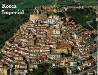
Villapiana, Amendolara, Capo Spulico and Rocca Imperiale are the last seaside resorts on the Ionian coast of Calabria.
Find out more about the Coasts & beaches | The Coast of the Gods | Violet Coast | Jasmine Coast | The Orange Coast | The coast of the Saracens | The coast of the Achei
Useful links
Coast and Sea of Abruzzo
Coast and Sea of Molise
Coast and Sea of Apulia